
You invested in a fleet of high-precision GNSS receivers and paired them with the perfect companion software to integrate into your existing workflow – maybe you even chose Asteri GNSS and use it with Orbitas or any one of our industry-leading integration partners, such as Milsoft, Futura, or ESRI. Your team then spent hours in the field staking points, collecting data, and meticulously adding and editing attributes for your assets. You might assume you’ll never need to collect this data again.
However, geospatial data is not a static snapshot but a dynamic measurement that changes over time due to factors such as geological movement, physical disruption of the stake, changes in satellite geometry, and atmospheric interference. This means that the perfect point you captured today may not be where your asset sits five years from now. Maintaining centimeter-level integrity requires a proactive strategy for mitigation and re-verification.
While we perceive the ground as stable, tectonic plates are in constant motion, contributing to crustal drift. In North America, the slow, steady movement of tectonic plates causes GPS markers to drift an average of 1.5 to 2.5 centimeters per year. For GNSS satellites that operate on a global frame, like WGS84, this is not an issue because it moves with the plates. However, many fixed maps use a frozen local frame, such as NAD83, necessitating mathematical corrections to maintain map accuracy for staking assets.
While a shift of 1.5 to 2.5 centimeters may not seem like a lot, over a decade, your digital map and the physical world can fall out of sync by nearly a foot. For utilities or high-pressure gas distribution, a 25 centimeter discrepancy isn’t just a nuisance, it’s a safety risk. If you’re digging near a high-pressure gas line, a foot is the difference between a safe dig and a disaster.
Maintaining long-term accuracy requires using software that understands coordinate transformations. Using Orbitas allows you to manage these shifts. By recording the epoch – the specific point in time the data was collected – Orbitas can mathematically adjust for tectonic drift, ensuring that your 2026 stake aligns perfectly with your 2032 data.
Accuracy isn’t just lost to the natural shifting of tectonic plates on the earth’s surface, but to features surrounding the collection site, such as trees, buildings, or other infrastructure. Some of the most common causes of accuracy degradation are signal blockages and multipath interference.
Signal blockages are most often caused by heavy tree canopy or tall buildings (urban canyon) that physically block the line of sight from your GNSS receiver to satellites, reducing the number of signals available to be received by your equipment.
In addition to blocking the signals altogether, tree canopy and tall buildings can also create multipath interference – signals that reflect off of buildings, ground, or water, taking longer to reach the receiver and potentially creating errors in position calculation.
The presence or other infrastructure, such as power lines, cellular towers, and other electronic devices can cause “noise” and disrupt signals. This type of disruption is known as EMI (electromagnetic interference).
While signal blockages physically stop data, satellite geometry has the potential to corrupt it. GNSS devices determine location through trilateration, measuring the distance from multiple satellites in relation to your own position. Poor satellite geometry occurs when satellites are clustered together in one part of the sky rather than spread out, forcing your GNSS receiver to only use satellites that are close together and resulting in DOP (dilution of precision) values. To a field engineer, this looks like a position that is “jumping” or “floating,” even if they have a clear view of those few satellites.
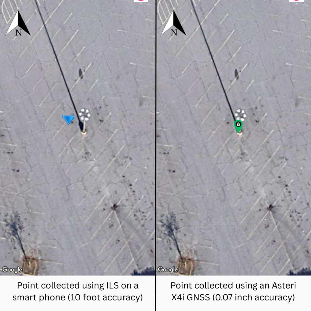
The best defense against signal blockages, multipath interference, and clustered satellites is a GNSS receiver capable of communicating with every major constellation: GPS, GLONASS, Galileo, and BeiDou. By having access to more satellites, the hardware can filter out reflected signals and maintain a fix in difficult environments where standard receivers or ILS (integrated location services) on a smart phone would otherwise fail.
Atmospheric interference is a major cause of GPS positioning errors, primarily caused by signal delays as signals pass through the ionosphere and troposphere. The ionosphere and troposphere cause distinct changes, which together affects GPS accuracy. As signals pass through the ionosphere, ionospheric plasma bends and slows the signals, which is exacerbated by solar activity such as solar flares. Then, as signals pass through the troposphere, tropospheric water vapor and pressure further distorts the signal, which results in inaccurate data.
To neutralize these atmospheric delays, high-precision workflows rely on RTK (real-time kinematic) corrections. By using a service like Orbitas Correct, powered by Point One Navigation, your GNSS receiver will benefit from enhanced accuracy. RTK enhances the accuracy of GPS by using a fixed base station on the ground as a known reference point to calculate and transmit real-time carrier signal-based corrections to a moving receiver.
The receiver then uses the data from both the satellites and the base station to compare and cancel any errors in measurement, providing a much more accurate position. This eliminates the noise in real-time, bringing your daily drift down from meters to 3 to 8 centimeters with Orbitas Correct Virtual RTK.
Another common but less acknowledged cause of data drift is the degradation of the physical collection site. Frost heave, soil creep, accidental strikes from landscaping equipment, or other phenomena, can physically move a marker, even if the “coordinates” in your system remain the same.
To combat potential shifts in your data caused by physical degradation or events outside of your control at the collection site, establish permanent, unmoveable benchmarks (such as a bolt in a concrete pad). Field crews should regularly “check in” to these points at the start of each day. If the Asteri receiver shows a discrepancy against the control point, you know immediately whether you’re dealing with a global shift or a local physical disruption.
|
Cause of Inaccuracy |
Impact on Data |
Primary Mitigation Strategy |
|
Atmospheric Noise |
Daily “jitter” or jumps |
Orbitas Correct (RTK Services) |
|
Signal Blockage |
Loss of precision in canopy/cities |
Asteri GNSS (Multi-constellation hardware) |
|
Tectonic Drift |
2cm+ annual consistent shift |
Orbitas (coordinate transformations) |
|
Physical Disruption |
Immediate, large-scale error |
Permanent control points and re-verification |
Maintaining an accurate digital twin of your physical assets is a marathon, not a sprint. At Tri-Global Technologies, we don’t just provide hardware; we provide a complete ecosystem – Asteri, Orbitas, and Orbitas Correct – designed to ensure that the data you capture today remains reliable tomorrow.
While Asteri and Orbitas Correct serve as a universal accuracy foundation compatible with almost any industry-standard platform like ESRI, Milsoft, and Futura, Orbitas remains the preferred software solution. Because they were engineered together, the “handshake” between Asteri hardware and Orbitas software optimizes your workflow, automating the complex mathematical transformations needed to fight data degradation.
Ready to stop the drift? Don’t let your data degrade over time. See how the Asteri and Orbitas ecosystem can bring centimeter-level certainty to your next project. We offer 2-week, no risk field trials of all of our solutions.
How long does a 2-week trial take to set up?
We know your crews are busy, which is why our products are plug and play. Our trial is designed to work with your schedule. When you’re ready, we ship you the hardware pre-configured to your local correction networks. Most teams are up and running within 5 to 10 minutes of opening the box.
Does weather (like heavy rain or clouds) affect my accuracy?
Surprisingly, no. While high-frequency signals like satellite TV can be washed out by heavy rain, GNSS L-band signals pass right through clouds and precipitation. However, extreme solar activity, such as solar flares often experienced in the summer months, can disturb the ionosphere, which is why using a multi-frequency receiver like Asteri is critical.
Why am I seeing “float” instead of “fix” on my device?
A “fix” means your receiver has successfully resolved the problems with satellite signals to a certain degree of accuracy. A “float” occurs when there is too much signal blockage or multipath interference for the math to lock in. If you frequently see “float” instead of “fix,” it’s a sign you need a receiver with better multi-constellation support. If you’re already using a multi-frequency receiver, it may mean that your device needs an evaluation or repair.
If I have sub-foot accuracy, do I still need to use RTK corrections?
This would depend on the accuracy demands of your projects. While sub-foot is great for locating a large asset like a manhole cover, it’s not precise enough to track year-over-year drift. Without RTK corrections, your data can still wander due to atmospheric changes. To future proof your data against annual drift, you need the centimeter-level foundation provided by RTK like Orbitas Correct.
Can I use the Asteri receiver with my existing collection software application?
Yes! Asteri was designed to be your universal accuracy foundation by streaming data in the industry-standard NMEA format via Bluetooth to almost any GIS application. While it works best with Orbitas because they were engineered to work together, Asteri will instantly upgrade the accuracy of any software you currently use in the field.
How often should I re-verify my “permanent” control points?
Field crews should check in to a known, unmoveable benchmark at the start of every work day. If your Asteri receiver shows a discrepancy against the control point, you can immediately determine if you are facing a global shift or a local physical disruption, such as a stake being struck by equipment.
Can software “fix” tectonic drift?
Yes. By recording the epoch (the specific point in time the data was collected), software like Orbitas can mathematically adjust for tectonic drift. This ensures that your 2026 stake aligns perfectly with your 2032 data, even as the North American plate moves 1.5 to 2.5 cm annually.
Can my Asteri GNSS receiver be repaired if it has been damaged?
Yes! Your investment into accuracy shouldn’t be fragile – that’s why Asteri is designed to survive the field. However, when the unthinkable happens, our team of repair technicians is ready to help. We’ll have your device working and back in the field in a matter of days.